SPCL AD 2.1 AERODROME LOCATION INDICATOR AND NAME
|
|
SPCL - PUCALLPA / INTL CAPITAN FAP DAVID ARMANDO ABENSUR RENGIFO
|
|
SPCL AD 2.2 AERODROME GEOGRAPHICAL AND ADMINISTRATIVE DATA
|
|
1
|
To be translated
|
082241S 0743427W
NIL
|
|
|
ARP coordinates and site at AD
|
2
|
To be translated
|
5 km al SW
|
|
|
Direction and distance from (city)
|
3
|
To be translated
|
Elev: 516 FT (157 M) / T: 32.5° C (Mean Low T: NIL)
|
|
|
Elevation / Reference temperature (Mean Low temperature)
|
4
|
To be translated
|
NIL
|
|
|
Geoid undulation at AD ELEV PSN
|
5
|
To be translated
|
4° W (2015)
|
|
|
MAG VAR / Annual change
|
6
|
To be translated
|
Aeropuertos del Perú S.A. - ADP
Av. Aeropuerto S/N altura km 5.5 Carretera Federico Basadre - Yarinacocha - Coronel Portillo - Ucayali
Tel: (061) 577329
Fax: (061) 594782
AFS: SPCLYDYX
|
|
|
AD Administration, address, telephone, telefax, telex, AFS
|
7
|
To be translated
|
IFR/VFR
|
|
|
Types of traffic permitted (IFR/VFR)
|
8
|
To be translated
|
NIL
|
|
|
Remarks
|
|
SPCL AD 2.3 OPERATIONAL HOURS
|
|
1
|
To be translated
|
H24
|
|
|
AD Administration
|
2
|
To be translated
|
1200 - 0600
|
|
|
Customs and immigration
|
3
|
To be translated
|
NIL
|
|
|
Health and sanitation
|
4
|
To be translated
|
H24
|
|
|
AIS Briefing Office
|
5
|
To be translated
|
H24
|
|
|
ATS Reporting Office (ARO)
|
6
|
To be translated
|
H24
|
|
|
MET Briefing Office
|
7
|
To be translated
|
H24
|
|
|
ATS
|
8
|
To be translated
|
y fuera de hora O/R
|
|
|
Fuelling
|
9
|
To be translated
|
NIL
|
|
|
Handling
|
10
|
To be translated
|
H24
|
|
|
Security
|
11
|
To be translated
|
NIL
|
|
|
De-icing
|
12
|
To be translated
|
COM H24
|
|
|
Remarks
|
|
SPCL AD 2.4 HANDLING SERVICES AND FACILITIES
|
|
1
|
To be translated
|
Todas las instalaciones donde se manipula carga proporcionada por compañías particulares. Servicios especializados Aeroportuarios (SEAS) son proporcionados por compañías particulares
|
|
|
Cargo-handling facilities
|
2
|
To be translated
|
To be translated: AVGAS 100
To be translated: TURBO A1
Fuel: AVGAS 100
Oil: TURBO
|
|
|
Fuel / oil types
|
3
|
To be translated
|
Camión cisterna. Capacidad: 4500 gal
|
|
|
Fuelling facilities/capacity
|
4
|
To be translated
|
NIL
|
|
|
De-icing facilities
|
5
|
To be translated
|
NIL
|
|
|
Hangar space for visiting aircraft
|
6
|
To be translated
|
NIL
|
|
|
Repair facilities for visiting aircraft
|
7
|
To be translated
|
NIL
|
|
|
Remarks
|
|
SPCL AD 2.5 PASSENGER FACILITIES
|
|
1
|
To be translated
|
En la ciudad
|
|
|
Hotels
|
2
|
To be translated
|
En el AD y la ciudad
|
|
|
Restaurants
|
3
|
To be translated
|
Taxis y ómnibus desde y hacia la ciudad
|
|
|
Transportation
|
4
|
To be translated
|
Primeros auxilios en el AD. Hospitales en la ciudad
|
|
|
Medical facilities
|
5
|
To be translated
|
To be translated: En el AD y la ciudad
To be translated: NIL
Bank: NIL
Post: NIL
|
|
|
Bank and Post Office
|
6
|
To be translated
|
En la ciudad
|
|
|
Tourist Office
|
7
|
To be translated
|
NIL
|
|
|
Remarks
|
|
SPCL AD 2.6 RESCUE AND FIRE FIGHTING SERVICES
|
|
1
|
To be translated
|
CAT A7
|
|
|
AD category for fire fighting
|
2
|
To be translated
|
02 vehículos contraincendios
|
|
|
Rescue equipment
|
3
|
To be translated
|
NIL
|
|
|
Capability for removal of disabled aircraft
|
4
|
To be translated
|
NIL
|
|
|
Remarks
|
|
SPCL AD 2.7 SEASONAL AVAILABILITY
|
|
1
|
To be translated
|
NIL
|
|
|
Types of clearing equipment
|
2
|
To be translated
|
NIL
|
|
|
Clearance priorities
|
3
|
To be translated
|
NIL
|
|
|
Use of material for movement area surface treatment
|
4
|
To be translated
|
NIL
|
|
|
Specially prepared winter runways
|
5
|
To be translated
|
NIL
|
|
|
Remarks
|
|
SPCL AD 2.8 APRONS, TAXIWAYS AND CHECK LOCATIONS DATA
|
|
1
|
To be translated
|
APN
|
Asfalto
Asphalt
|
PCN 49/F/C/X/T
|
|
|
|
Apron surface and strength
|
2
|
To be translated
|
ALFA
|
23 M
|
Asfalto
Asphalt
|
PCN 34/F/C/X/T
|
BRAVO
|
23 M
|
Asfalto
Asphalt
|
PCN 32/F/B/X/T
|
|
|
|
Taxiway width, surface and strength
|
3
|
To be translated
|
NIL
|
|
|
Altimeter checkpoint location and elevation
|
4
|
To be translated
|
NIL
|
|
|
VOR checkpoints
|
5
|
To be translated
|
NIL
|
|
|
INS checkpoints
|
6
|
To be translated
|
VOR/DME: 205º 1.0 NM letrero en RWY 02, no instalado en proceso de implementación.
Coeficiente de fricción (rozamiento):0.67
|
|
|
Remarks
|
|
SPCL AD 2.9 SURFACE MOVEMENT GUIDANCE AND CONTROL SYSTEM AND MARKINGS
|
|
1
|
To be translated
|
Señales de guía de rodaje en todas las intersecciones entre TWYy RWY y en todos los puntos de espera. Líneas de guía en la plataforma. Guía visual de estacionamiento en los puestos de aeronaves.
|
|
|
Use of aircraft stand ID signs, TWY guide lines and visual docking/parking guidance system of aircraft stands
|
2
|
To be translated
|
Puntos de espera en todas las intersecciones TWY/RWY, señalados. Bordes iluminados solo TWY B. Designación, THR, TDZ, borde, eje de pista, según corresponda, sañalados. THR, borde y extremos iluminados.
|
|
|
RWY and TWY markings and LGT
|
3
|
To be translated
|
NIL
|
|
|
Stop bars and runway guard lights
|
4
|
To be translated
|
NIL
|
|
|
Other runway protection measures
|
5
|
To be translated
|
NIL
|
|
|
Remarks
|
|
SPCL AD 2.10 AERODROME OBSTACLES
|
|
To be translated / In Area 2
|
To be translated
|
To be translated
|
To be translated
|
To be translated
|
To be translated
|
To be translated
|
OBST ID / Designation
|
OBST type
|
OBST position
|
ELEV/HGT
|
Markings/
Type,
colour
|
Remarks
|
a
|
b
|
c
|
d
|
e
|
f
|
|
To be translated / In Area 3
|
To be translated
|
To be translated
|
To be translated
|
To be translated
|
To be translated
|
To be translated
|
OBST ID / Designation
|
OBST type
|
OBST position
|
ELEV/HGT
|
Markings/
Type,
colour
|
Remarks
|
a
|
b
|
c
|
d
|
e
|
f
|
|
SPCL AD 2.11 METEOROLOGICAL INFORMATION PROVIDED
|
|
1
|
To be translated
|
EMA
|
|
|
Associated MET Office
|
2
|
To be translated
|
H24 NO AVBL
H24
h24
|
|
|
Hours of service
MET Office outside hours
|
3
|
To be translated
|
OMA/SPJC
24 horas
|
|
|
Office responsible for TAF preparation
Period of validity
|
4
|
To be translated
|
NIL
|
|
|
Trend forecast
Interval of issuance
|
5
|
To be translated
|
Consulta personal
|
|
|
Briefing/consultation provided
|
6
|
To be translated
|
Pronóstico, Observaciones e Informes MET. ES
|
|
|
Flight documentation
Language(s) used
|
7
|
To be translated
|
NIL
|
|
|
Charts and other information available for briefing or consultation
|
8
|
To be translated
|
Terminal AMHS CADAS
|
|
|
Supplementary equipment available for providing information
|
9
|
To be translated
|
TWR SPCL
|
|
|
ATS units provided with information
|
10
|
To be translated
|
NIL
|
|
|
Additional information (limitation of service, etc.)
|
|
SPCL AD 2.12 RUNWAY PHYSICAL CHARACTERISTICS
|
|
To be translated
|
To be translated
|
To be translated
|
To be translated
|
To be translated
|
To be translated
|
RWY Designator
|
TRUE BRG
|
Dimension of RWY (M)
|
Strength (PCN) and surface of RWY and SWY
|
THR coordinates
RWY end coordinates
THR geoid undulation
|
THR elevation and highest elevation of TDZ of precision APP RWY
|
1
|
2
|
3
|
4
|
5
|
6
|
02
|
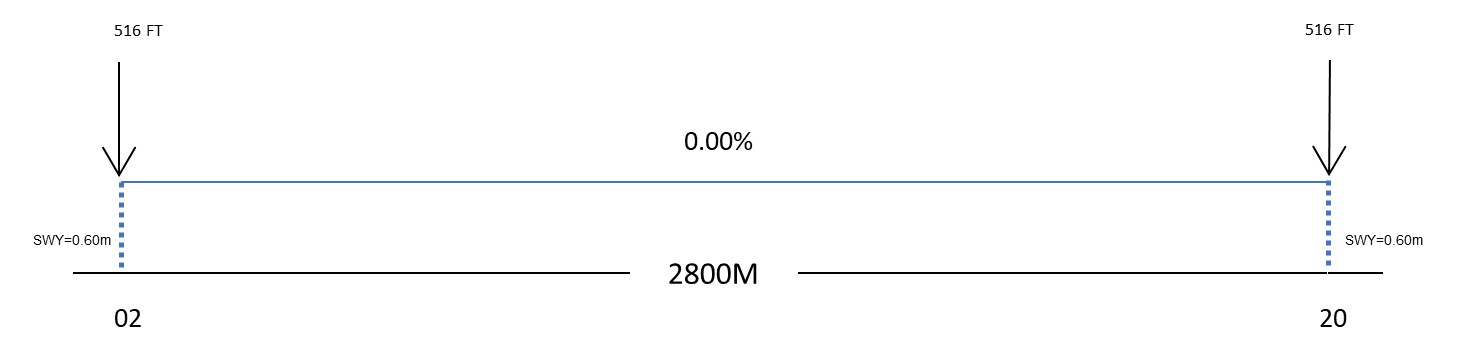
020.00°
|
2800 x 45
|
PCN 46/F/C/X/T
Asfalto
Asphalt
Coeficiente de fricción (rozamiento): 0.67
SWY: NIL
|
082323.41S
0743443.15W
END: NIL
GUND: NIL
|
THR 516 FT
TDZ: NIL
|
20
|
200.00°
|
2800 x 45
|
PCN 46/F/C/X/T
Asfalto
Asphalt
Coeficiente de fricción (rozamiento): 0.67
SWY: NIL
|
082157.76S
0743411.80W
END: NIL
GUND: NIL
|
THR 516 FT
TDZ: NIL
|
|
To be translated
|
To be translated
|
To be translated
|
To be translated
|
To be translated
|
To be translated
|
To be translated
|
To be translated
|
RWY Designator
|
Slope of RWY-SWY
|
SWY dimensions (M)
|
CWY dimensions (M)
|
Strip dimensions (M)
|
RESA dimensions (M)
|
Location/
description of arresting system
|
OFZ
|
1
|
7
|
8
|
9
|
10
|
11
|
12
|
13
|
02
|
NIL
|
60 x 45
|
NIL
|
2920 x 150
|
NIL
|
NIL
|
NIL
|
20
|
NIL
|
60 x 45
|
NIL
|
2920 x 150
|
NIL
|
NIL
|
NIL
|
|
To be translated
|
To be translated
|
RWY Designator
|
Remarks
|
1
|
14
|
02
|
NIL
|
20
|
NIL
|
|
|
|
SPCL AD 2.13 DECLARED DISTANCES
|
|
To be translated
|
TORA
(M)
|
TODA
(M)
|
ASDA
(M)
|
LDA
(M)
|
To be translated
|
RWY Designator
|
Remarks
|
1
|
2
|
3
|
4
|
5
|
6
|
02
|
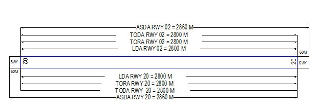
2800
|
2800
|
2860
|
2800
|
NIL
|
20
|
2800
|
2800
|
2860
|
2800
|
NIL
|
|
|
|
SPCL AD 2.14 APPROACH AND RUNWAY LIGHTING
|
|
To be translated
|
To be translated
|
To be translated
|
To be translated
|
To be translated
|
To be translated
|
RWY Designator
|
APCH LGT type LEN INTST
|
THR LGT colour WBAR
|
VASIS (MEHT) PAPI
|
TDZ, LGT LEN
|
RWY Centre Line LGT Length, spacing, colour, INTST
|
1
|
2
|
3
|
4
|
5
|
6
|
02
|
SALS
CAT1
250 M
LIH
|
Verde
Green
|
PAPI
3°
53.53 FT
|
NIL
|
NIL
|
20
|
NIL
|
Verde
Green
|
PAPI
3°
54.1 FT
|
NIL
|
NIL
|
|
To be translated
|
To be translated
|
To be translated
|
To be translated
|
To be translated
|
RWY Designator
|
RWY edge LGT LEN, spacing colour INTST
|
RWY End LGT colour WBAR
|
SWY LGT LEN
colour
|
Remarks
|
1
|
7
|
8
|
9
|
10
|
02
|
Bianco
White
2800 M, 60 M, LIH
|
Rosso
Red
|
NIL
|
NIL
|
20
|
Bianco
White
2800 M, 60 M, LIH
|
Rosso
Red
|
NIL
|
NIL
|
|
SPCL AD 2.15 OTHER LIGHTING, SECONDARY POWER SUPPLY
|
|
1
|
To be translated
|
ABN: Edificio TWR FLG W/G EV 2.5 SEC, HN/IMC
ABN
|
|
|
ABN/IBN location, characteristics and hours of operation
|
2
|
To be translated
|
450 m de THR 02 LGTD
|
|
|
LDI location and LGT Anemometer location and LGT
|
3
|
To be translated
|
To be translated/Taxiway edge:
ALFA
BRAVO
|
|
|
TWY edge and centre line lighting
|
4
|
To be translated
|
Para todas las luces en el AD. 15 s
|
|
|
Secondary power supply/switch-over time
|
5
|
To be translated
|
NIL
|
|
|
Remarks
|
|
SPCL AD 2.16 HELICOPTER LANDING AREA
|
|
1
|
To be translated
|
NIL
|
|
|
Coordinates TLOF or THR of FATO
Geoid undulation
|
2
|
To be translated
|
NIL
|
|
|
TLOF and/or FATO elevation M/FT
|
3
|
To be translated
|
NIL
|
|
|
TLOF and FATO area dimensions, surface, strength, marking
|
4
|
To be translated
|
NIL
|
|
|
True BRG of FATO
|
5
|
To be translated
|
NIL
|
|
|
Declared distance available
|
6
|
To be translated
|
NIL
|
|
|
APP and FATO lighting
|
7
|
To be translated
|
NIL
|
|
|
Remarks
|
|
SPCL AD 2.17 ATS AIRSPACE
|
|
To be translated
|
To be translated
|
To be translated
|
To be translated
|
To be translated
|
To be translated
|
To be translated
|
Designation and lateral limits
|
Vertical limits
|
Airspace classification
|
ATS unit call sign Language(s)
|
Transition altitude
|
Hours of applicability
|
Remarks
|
1
|
2
|
3
|
4
|
5
|
6
|
7
|
ATZ SPCL
Circulo con centro en 082233S 0743420W con radio de 5 NM.
Circular area centered on 082233S 0743420W within a 5 NM radius.
|
|
D
|
NIL
|
NIL
|
NIL
|
NIL
|
CTR SPCL
Circulo con centro en 082233S 0743420W con radio de 10 NM.
Circular area centered on 082233S 0743420W within a 10 NM radius.
|
|
D
|
NIL
|
NIL
|
NIL
|
NIL
|
PUCALLPA TMA
Circulo con centro en 082233S 0743420W con radio de 55 NM.
Circular area centered on 082233S 0743420W within a 55 NM radius.
|
|
NIL
|
NIL
|
NIL
|
NIL
|
NIL
|
|
SPCL AD 2.18 ATS COMMUNICATION FACILITIES
|
|
To be translated
|
To be translated
|
To be translated
|
To be translated
|
To be translated
|
To be translated
|
To be translated
|
Service
designation
|
Callsign
|
Frequency
|
SATVOICE
|
Logon address
|
Hours of operation
|
Remarks
|
1
|
2
|
3
|
4
|
5
|
6
|
7
|
ATIS SPCL
|
AEROPUERTO PUCALLPA
|
130.900 MHZ
|
NIL
|
NIL
|
H24
|
NIL
|
EMERGENCIA
|
EMERGENCIA
|
121.500 MHZ
|
NIL
|
NIL
|
1200-0600 (UTC +5)
|
y O/R
|
TWR
|
PUCALLPA TORRE
|
118.100 MHZ
|
NIL
|
NIL
|
H24
|
NIL
|
|
SPCL AD 2.19 RADIO NAVIGATION AND LANDING AIDS
|
|
To be translated
|
To be translated
|
To be translated
|
To be translated
|
To be translated
|
To be translated
|
To be translated
|
To be translated
|
Type of aid
MAG VAR
CAT of ILS/MLS
DECL
|
ID
|
Frequency
|
Hours of operation
|
Site of transmitting antenna coordinates
|
Elevation of DME transmitting antenna
|
Service
volume
radius
from GBAS
reference
Point
|
Remarks
|
1
|
2
|
3
|
4
|
5
|
6
|
7
|
8
|
VOR/DME
(04° W)
|
PUL
|
116.700 MHZ
CH 114X
|
H24
|
082233.5S
0743420.3W
|
537 FT
|
NIL
|
NIL
|
|
SPCL AD 2.20 LOCAL AERODROME REGULATIONS
|
|
|
|
The Coronel FAP David Abensur Rengifo International Airport is equipped with:
-
Aerodrome Manual
-
Apron user Manual
|
2 Taxiing to and from Aircraft stands
|
2.1 ADP S.A will assign through TWR an aircraft stand number to the arriving aircraft.
2.2 Departing flights must contact TWR to indicate engines start and towing and shall obtain ATC clearance and instructions before taxiing at the frequency118.1 MHz.
2.3 Aircraft with medium and high wake turbulence category, when taxiing to the runway in use, must make the turn with power reduced to the minimum recommended at the aircraft stands.
|
3 Parking area for small aircraft (General Aviation)
|
3.1 There is no exclusive parking area for small aircraft.
|
4 Helicopter Parking area
|
4.1 There is no exclusive helicopter parking area.
|
5 Apron - Taxiing in winter conditions
|
|
|
|
|
6.1 All aircraft must vacate the apron with push-back assistance.
6.2 Aircraft Stand Number 8 not available.
6.3 Due to apron capacity, overnight parking is not allowed. For further information contact AEROPUERTOS DEL PERÚ Pucallpa by email at oliver.vela@adp.com.pe and by phone at 961666872.
|
7 School and Training Flights – Technical Test Flights– Use of Runway
|
7.1 Training and technical test flights will be carried out with the authorization of the DGAC.
|
8 Helicopter Traffic – Limitations
|
No limitations, follow ATS instructions.
|
9 Removal of disabled Aircraft from Runways
|
In case of an aircraft is rendered disabled on a runway, it is the duty of the owner or user of that aircraft to ensure that it is removed as soon as possible. Ifthe owner does not remove a disabled aircraft from the runway as soon as possible, it shall be removed by the aerodrome authorities at the owner’s or user’s expense.
|
|
|
|
|
SPCL AD 2.21 NOISE ABATEMENT PROCEDURES
|
|
|
|
SPCL AD 2.22 FLIGHT PROCEDURES
|
|
|
|
Flights shall be at 2000 ft or higher to the East of the airport (over the city).
|
2 Procedures for IFR flights within TMA
|
Instrument flight procedures (SID, STAR, Approach, Holding, etc) must NOT be modified. The outbound and inbound headings, minima of descent, etc., have been calculated considering the surrounding topography, therefore, any variation in them could reduce the margin of protection against obstacles of the corresponding segment, dangerously bringing the aircraft closer to the obstacles.
Flights should be to the west (W) of the aerodrome, if necessary and if weather and traffic conditions permit, due to the proximity of high terrain to the east of the aerodrome.
|
|
|
|
|
|
|
In the event of communications failure, the pilot shall act in accordance with the procedures for communications failure set out in ICAO Annex 2.
|
5 Procedures for VFR flights within TMA
|
Whenever traffic conditions permit, ATC clearance will be given for VFR flights under the conditions described below:
-
A flight plan for requesting ATC clearance, containing items 7 to 18 and indicating the purpose of the flight, shall be submitted.
-
It is only possible to release from the ATC clearance when prior permission has been obtained.
-
The flight shall be conducted with a vertical visual reference to the ground.
-
Two-way radio communication will be established at the frequency 118.1 MHz.
|
6 Procedures for VFR flights within CTR
|
-
A flight plan will be filled out for the corresponding flight.
-
The ATC clearance will be obtained from the Control Tower.
-
It is only possible to release from the ATC clearance when prior permission has been obtained.
-
The flight shall be conducted with a vertical visual reference to the ground.
Two-way radio communication will be established at the frequency 118.1 MHz before the flight enters the control area.
|
SPCL AD 2.23 ADDITIONAL INFORMATION
|
|
1 Local Flight Restrictions
|
There is a daily activity of vultures and other small birds circling the runway and crossing the path of Runway 02/20. Pilots should take precautions when landing and take-off.
Lights at 1.5 NM on the road to the SOUTHWEST of the runway final approach heading may be mistaken for Runway 02.
Control tower without visibility between 2000 m to 2400 m from Runway 02 due to radar installation. Pilots caution on landing and take- off.
|
SPCL AD 2.24 CHARTS RELATED TO AN AERODROME
|
|
Charts
|
Pages
|
1_PLANO AERODROMO_SPCL.pdf
|

|
2_CARTA DE AREA_SPCL.pdf
|
|
3_DESCRIPCION CARTA DE AREA_SPCL.pdf
|
|
|
|
CARTAS /
CHARTS
|
NOMBRE /
NAME
|
PÁGINA /
PAGES
|
|
1 Plano de Aeródromo - OACI
|
|
AD 2 SPCL 7 |
|
2 Descripción Carta de Área - OACI (rutas de salida, llegada y tránsito)
|
|
AD 2 SPCL 9 |
|
3 Carta de Área - OACI (rutas de salida, llegada y tránsito)
|
|
AD 2 SPCL 9A |
|
4 Carta de Salidas Normalizadas - Vuelo por Instrumentos (SID) - OACI
|
RWY 20 COCOS 1 |
AD 2 SPCL 11 |
|
5 Carta de Llegadas Normalizadas - Vuelo por Instrumentos (STAR) - OACI
|
RWY 02 MIKAR 1A |
AD 2 SPCL 13 |
|
RWY 02 RNAV MIKAR 1B
|
AD 2 SPCL 13A |
|
6 Carta de Aproximación por Instrumentos (IAC) - OACI
|
VOR W RWY 02 |
AD 2 SPCL 15 |
|
VOR V RWY 02
|
AD 2 SPCL 15A |
|
VOR U RWY 02
|
AD 2 SPCL 15B |
|
VOR A RWY 20
|
AD 2 SPCL 15C |
|
7 Carta de Aproximación Visual (VAC) - OACI
|
|
AD 2 SPCL 17 |
|
SPCL AD 2.25 VISUAL SEGMENT SURFACE (VSS) PENETRATION
|
|