
Note: This AIP supplement supersedes the AIP Supplement 04/24
This supplement is aimed at providing information to the crews about the second phase (Phase 2) of the rehabilitation work of the movement area at Piura Airport, resulting from the PRMLA SPUR work that will be carried out on runways, taxiway and apron. During this second phase:
The start and end dates of each phase will be informed in a timely manner via NOTAM.
This supplement is aimed at providing information to the crews about the second phase (Phase 2) of the rehabilitation work of the movement area at Piura Airport, resulting from the PRMLA SPUR work that will be carried out on runways, taxiway and apron. During this second phase:
- Closure of RWY 19/01.
- Closure of TWY A1.
- TWY C available as temporary RWY 19L/01R with features described below.
- TWY A, and TWY B available for taxiing.
- Apron capacity: two (02) aircraft stands, subject to operations for category A, B and C aircraft. Once the aircraft has taken position in the assigned PEA, another aircraft will be authorized to move on the apron to go to the maneuvering area.
The start and end dates of each phase will be informed in a timely manner via NOTAM.
Cuadro Nº 1
1.1.1.
RWY 19L/01R will not have runway edge lighting or approach lighting system.
1.1.2.
RWY 19L will have a set of Precision Approach Path Indicator (PAPI).
1.1.3.
RWY 01R will not have a set of Precision Approach Path Indicator (PAPI).
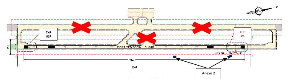
The following operational restrictions apply during PRMLA work:
2.1 The airport's operating hours will be from 11:00 UTC (06:00 hrs) to 23:00 UTC (18:00 hrs).
2.2 Take-offs on RWY 01R are not allowed.
2.1 The airport's operating hours will be from 11:00 UTC (06:00 hrs) to 23:00 UTC (18:00 hrs).
2.2 Take-offs on RWY 01R are not allowed.
3.1. Standard Instrument Departures (SID). Provisional SIDs EGASI 1L, PAGUR 1L, XOGOS 1L and SIDOM 1L are established (see Annex 1).
3.2. Standard instrument arrivals (STAR) available to IAF and then continue VFR.
3.3. Instrument Approach (IAC) Procedures. All published IACs are suspended.
3.4. Traffic routing under VFR flight rules Approaching aircraft will use authorized STAR until the initial approach fix (IAF) and then continue in VFR.
3.2. Standard instrument arrivals (STAR) available to IAF and then continue VFR.
3.3. Instrument Approach (IAC) Procedures. All published IACs are suspended.
3.4. Traffic routing under VFR flight rules Approaching aircraft will use authorized STAR until the initial approach fix (IAF) and then continue in VFR.
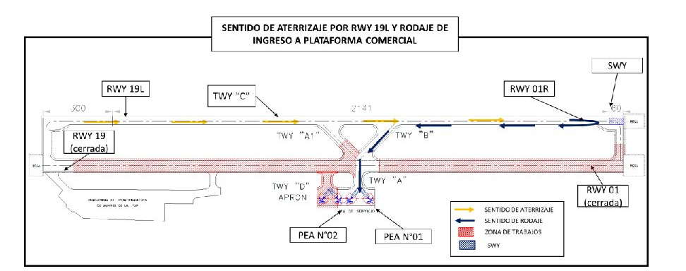
a. Aircraft heading to commercial ramp:
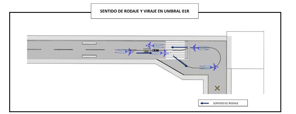
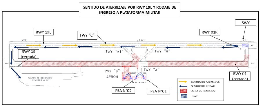
a.1 RWY 19L: Aircraft landing on runway 19L make a turn at the end of the runway at threshold 01R (see Image N°04), and then return along the runway, vacating it via taxiway B and heading to the assigned PEA (see Image N°03).
a.1 RWY 19L: Aircraft landing on runway 19L make a turn at the end of the runway at threshold 01R (see Image N°04), and then return along the runway, vacating it via taxiway B and heading to the assigned PEA (see Image N°03).
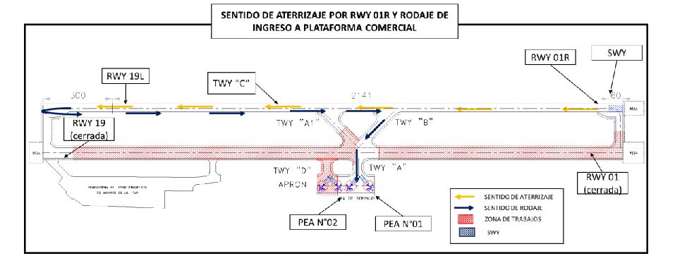
a.2 RWY 01R:
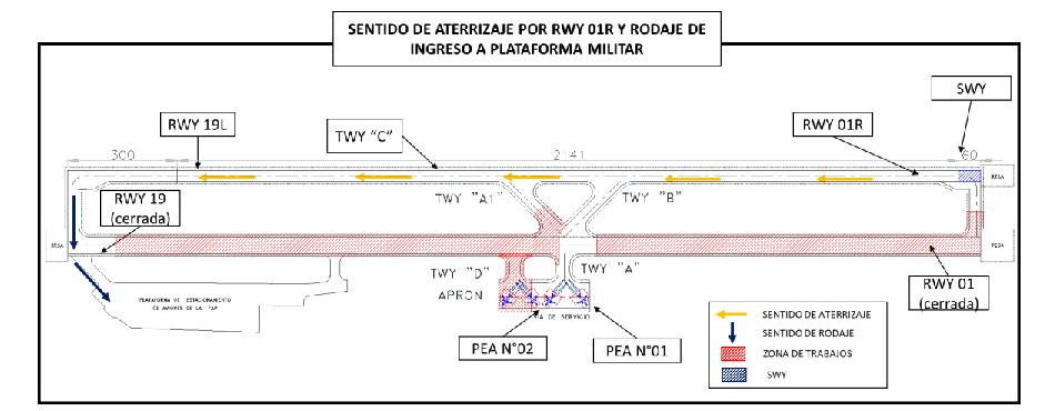
Aircraft landing on runway 01R (no PAPI lights) make a turn on the runway turning bay set up 300m from threshold 19L, and then return along the runway, vacating it via taxiway A and heading to the assigned PEA (see image N°05).
b. Aircraft heading to military ramp:
b.1 RWY 19L: Aircraft landing on runway 19L make a turn at the end of the runway at threshold 01R and then return along the runway, vacating it through threshold 19 of RWY 19/01 and heading via Militar Norte taxiway to enter to the assigned PEA (See Image N°06).
b.1 RWY 19L: Aircraft landing on runway 19L make a turn at the end of the runway at threshold 01R and then return along the runway, vacating it through threshold 19 of RWY 19/01 and heading via Militar Norte taxiway to enter to the assigned PEA (See Image N°06).
b.2 RWY 01R:
Aircraft landing on runway 01R (no PAPI lights) taxi towards threshold 19 of RWY 19/01 and heading via Militar Norte taxiway to enter to the assigned PEA (See image N°07).
a. Aircraft leaving commercial ramp:
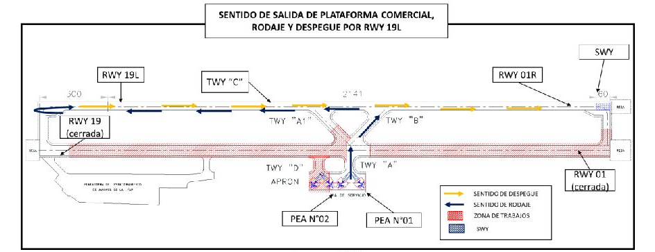
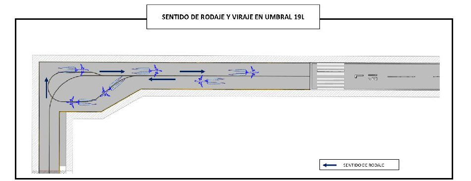
a.1 RWY 19L: Aircraft leaving the commercial ramp after receiving taxi clearance will proceed via TWY A-TWY B and the main runway, taxiing to the runway turning bay set up 300 m from threshold 19L (see Image N°09), to return and set take-off position until threshold 19L in accordance with the instructions provided by Piura Control Tower (See Image N°08.
a.1 RWY 19L: Aircraft leaving the commercial ramp after receiving taxi clearance will proceed via TWY A-TWY B and the main runway, taxiing to the runway turning bay set up 300 m from threshold 19L (see Image N°09), to return and set take-off position until threshold 19L in accordance with the instructions provided by Piura Control Tower (See Image N°08.
b. Aircraft leaving military ramp:
b.1 RWY 19L: Aircraft leaving the military ramp after receiving taxi clearance, will proceed via Militar Norte taxiway, threshold 19 of RWY 19/01, continuing to their holding point. Once authorization has been received to enter RWY 19L/01R, they will go to take-off position on RWY 19L (See Image N°10).
b.2 RWY 01R: Take-offs from RWY 01R are not allowed due to obstacles that interfere with the take-off climb Obstacle Clearance Surface (OCS) for this runway.
b.1 RWY 19L: Aircraft leaving the military ramp after receiving taxi clearance, will proceed via Militar Norte taxiway, threshold 19 of RWY 19/01, continuing to their holding point. Once authorization has been received to enter RWY 19L/01R, they will go to take-off position on RWY 19L (See Image N°10).
b.2 RWY 01R: Take-offs from RWY 01R are not allowed due to obstacles that interfere with the take-off climb Obstacle Clearance Surface (OCS) for this runway.
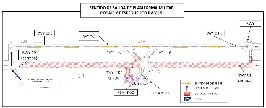
b.3 RWY 01R
: Take-off from RWY 01R are not allowed due to obstacles that interfere with the take-off climb OCS for this runway.
PROVISIONAL STANDARD INSTRUMENT DEPARTURE (SID)

The following obstacles are identified in the assessment of obstacle clearance surfaces as interfering the transition surface of RWY 19L/01R as a temporary runway:
Likewise, the following air navigation aid equipment is located at the following coordinates: